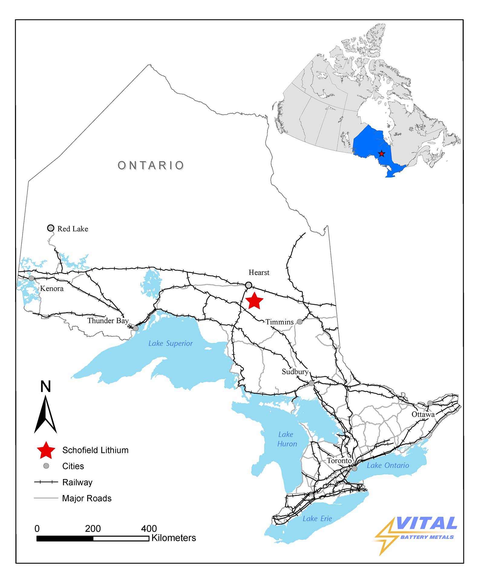
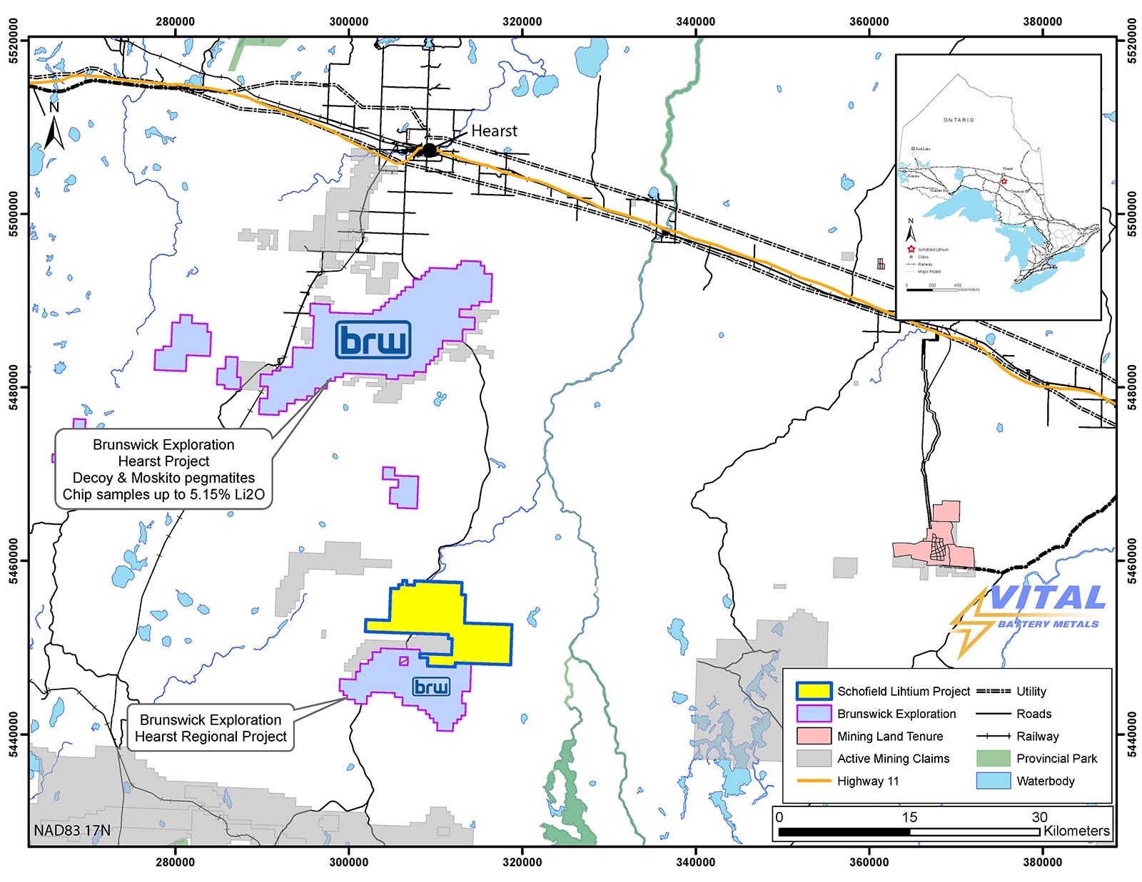
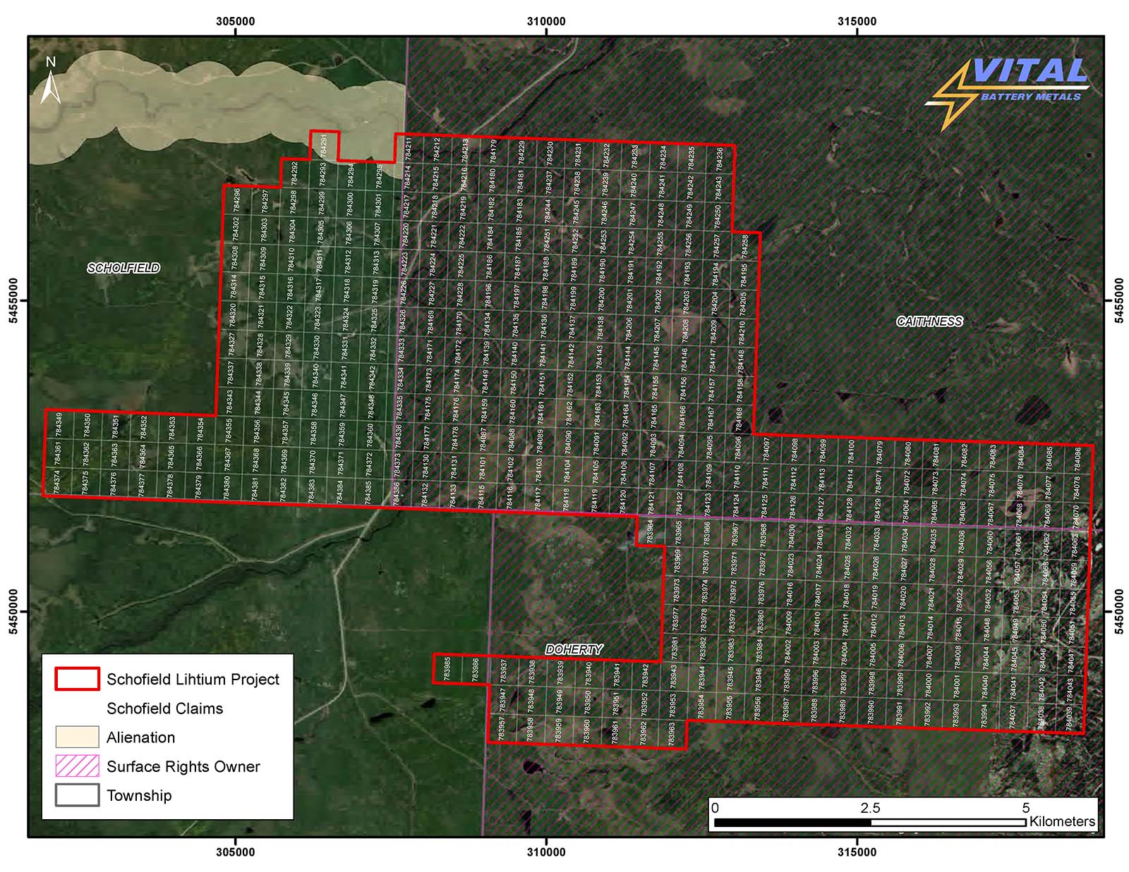
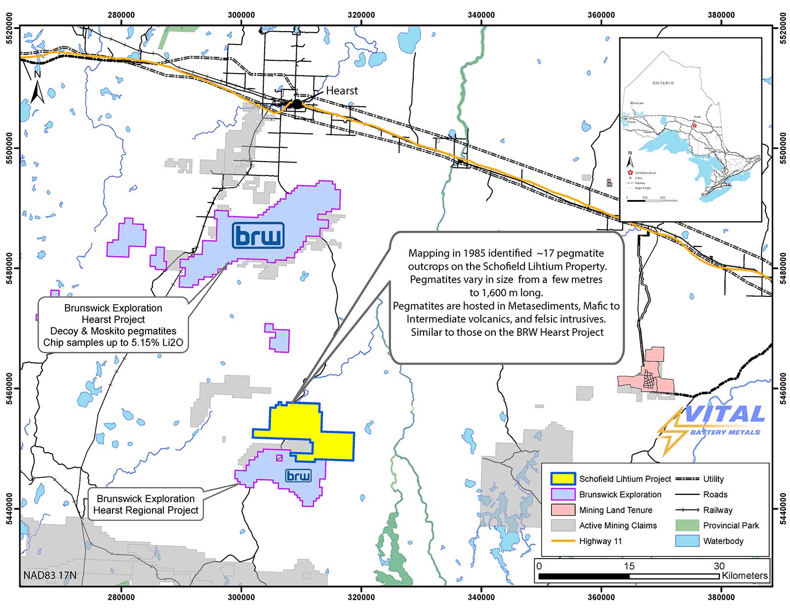
The Project consists of 416 single-cell mining claims covering approximately 8,824 hectares and is located approximately 60km south of Hearst, Ontario. The Project is easily accessible by logging road networks and is directly south of the Brunswick Exploration’s Hurst Lithium project.
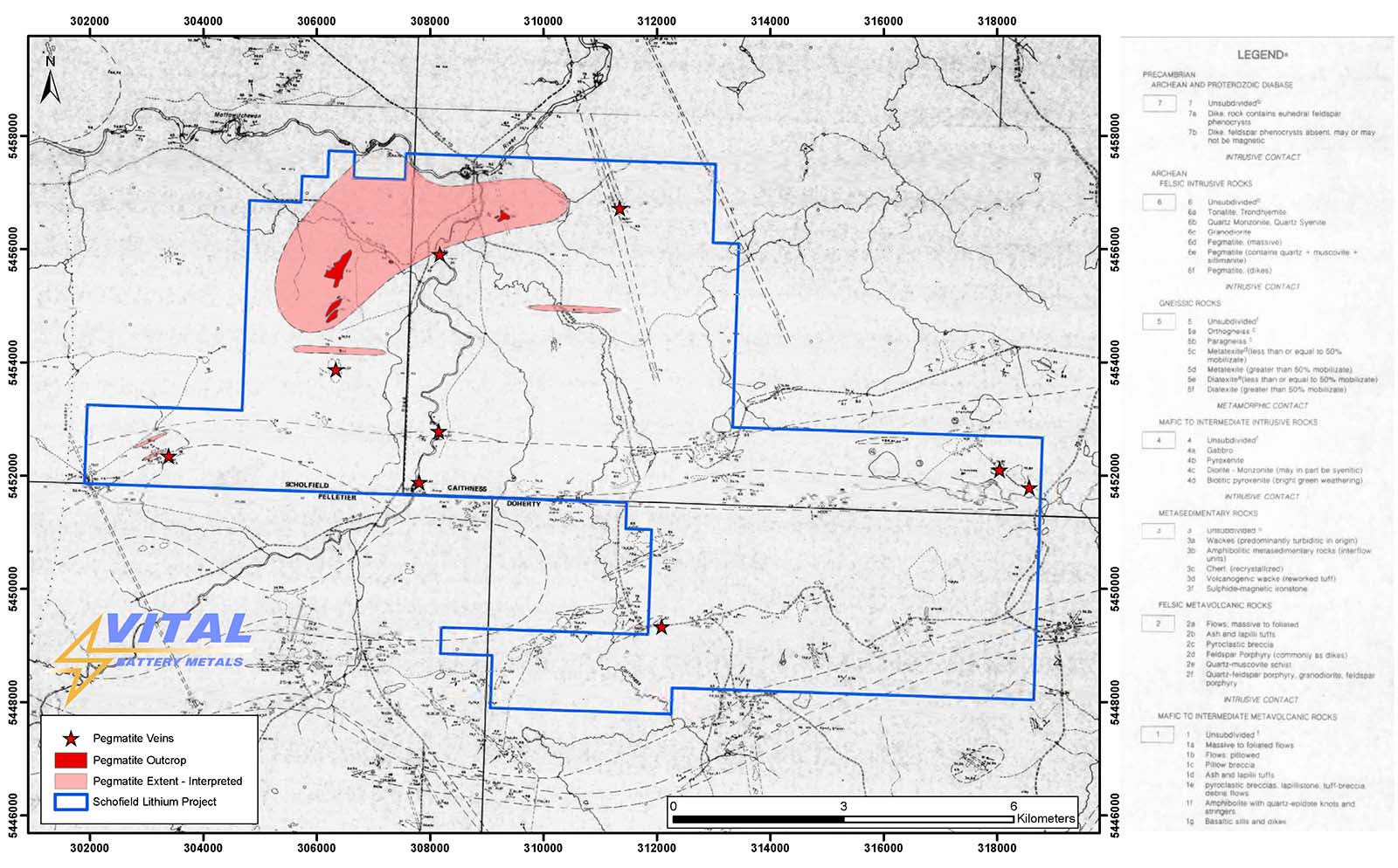
There are 17 mapped pegmatite outcrops on the Project which have not been thoroughly tested for LCT (Lithium, Cesium, Tantalum) mineralization.
Located within the Quetico subprovince and contains a variety of evolved S-type granitoids and pegmatites hosted by metamorphosed sediments (paragneisses) and metavolcanics.
Click image to enlarge.
Location
Schofield, Cathiness, Doherty Townships, Porcupine Mining Division. The Project 61km drive from Hearst, 583 South onto Caithness Rd which runs through the centre of the property and there are arterial logging roads allowing access to the eastern and western extents of the property.
Click image to enlarge.
Click image to enlarge.
PREVIOUS WORK
PREVIOUS WORK
The project area has been under explored but has seen sporadic exploration for gold, base, metals and more recently diamonds from 1960 to 2001. No work completed on the project has been focused on the economic potential of the pegmatites present.
ADJACENT PROPERTIES
ADJACENT OPERTIES
Brunswick Exploration “Hearst” & Lowther Projects
~30km south of Brunswick Explorations Hearst Property (which includes the Lowther Pegmatite Property)
Brunswick Exploration’s Hearst package has shown 5.15% Li2O in historical chip samples (see Brunswick Exploration Inc. news release dated October 3, 2022).
Click image to enlarge.
Geology
Project is underlain by metasediments, mafic to intermediate volcanics, mafic to intermediate intrusives and felsic intrusives and are crosscut by predominantly northwest trending dikes. Regional grade of metamorphism is middle to upper greenschist facies.
Claims were staked based on preferred geologic environments and historical mapping, most of this area has seen little to no exploration. The project is located within the Quetico Subprovince and contains a variety of evolved S-type granitoids and pegmatites hosted by metamorphosed sediments (paragneisses) and metavolcanics.
Mapping completed in 1985 by Berger et al indicates that there are at least 20 pegmatite outcrops on the property. These range from massive pegmatites, pegmatites with quartz + muscovite + sillimanite. The pegmatites mapped vary in size from decimetre veins to ~1600m x ~500m. The size and extent of the pegmatites has yet to be confirmed by the company.
Summary of Quetico Subprovince
The Quetico subprovince represents an east-west trending zone of highly deformed rocks fault bound to the north by the Wabigoon Subprovince and south by the Wawa Supbrovince. For the most part the rocks of this terrane consist of metasedimentary rocks metamorphosed to upper amphibolite facies. These rocks are isoclinally folded about an east-west axis and are pervasively intruded by granitic bodies, many of which are anatectic in origin. The granitic rocks characteristically contain abundant paragneiss inclusions which contain minerals such as muscovite, garnet, and cordierite
The Quetico Subprovince is host to several pegmatite swarms such as Georgia Lake, Lowther, and Wisa Lake. The pegmatites in the Quetico Subprovince are hosted by medium-grade unmigmatized metawacke with subordinate interbedded metapelite (e.g., spodumene-subtype Wisa Lake pegmatite and albite spodumene-type Georgia Lake pegmatites) and by their parent granite (e.g., petalite-subtype MNW pegmatite and lepidolite-subtype Lowther Township pegmatite) (Pye 1965; Breaks, Selway and Tindle 2003a, 2003b).
Click image to enlarge.
Click image to enlarge.
Click image to enlarge.
REFERENCES
1 – Berger, B.R., MacMillan, D.W., and P.L. Roy 1986: Precambrian Geology of Caithness, and Parts of Schofield, Pellitier, and Doherty Townships, Hearst-Kapuskasing Area, Algoma and Cochrane Districts; Ontario Geological Survey, Geological Series – Preliminary Map P.2961. Scale 1:31,680. Geology 1985.
2 – Breaks, F.W., Selway, J.B., and Tindle, A.G., 2003, Fertile peraluminuous granites andrelated rare-element pegmatite mineralization, Superior Province, northwest and northeast Ontario: Operation Treasure Hunt, Ontario Geological Survey, Open File Report 6099, 179 pp.
QUALIFIED PERSON
QUALIFIED PERSON
The technical information contained in this news release has been reviewed and approved by Mr. Garry Clark, P.Geo., a “Qualified Person” as defined in National Instrument 43-101 – Standards of Disclosure for Mineral Projects.
The reader is cautioned that the mineralization on nearby or adjacent properties does not necessarily indicate that any mineral resources may be discovered on the Schofield Lithium Project, or if discovered, that such resources would be economically recoverable.