Based on its past exploration history, favourable geological and tectonic setting, presence of surface copper mineralization, and the results of present study, experts have concluded that the Vent Copper Property is a property of merit and possesses a good potential for discovery of copper, and other sulphide mineralization.
The Property has direct access to major highway transportationwhich crosses part of the Property.
Good road access together with availability of exploration and mining services in the vicinitymakes it a worthy mineral exploration target.
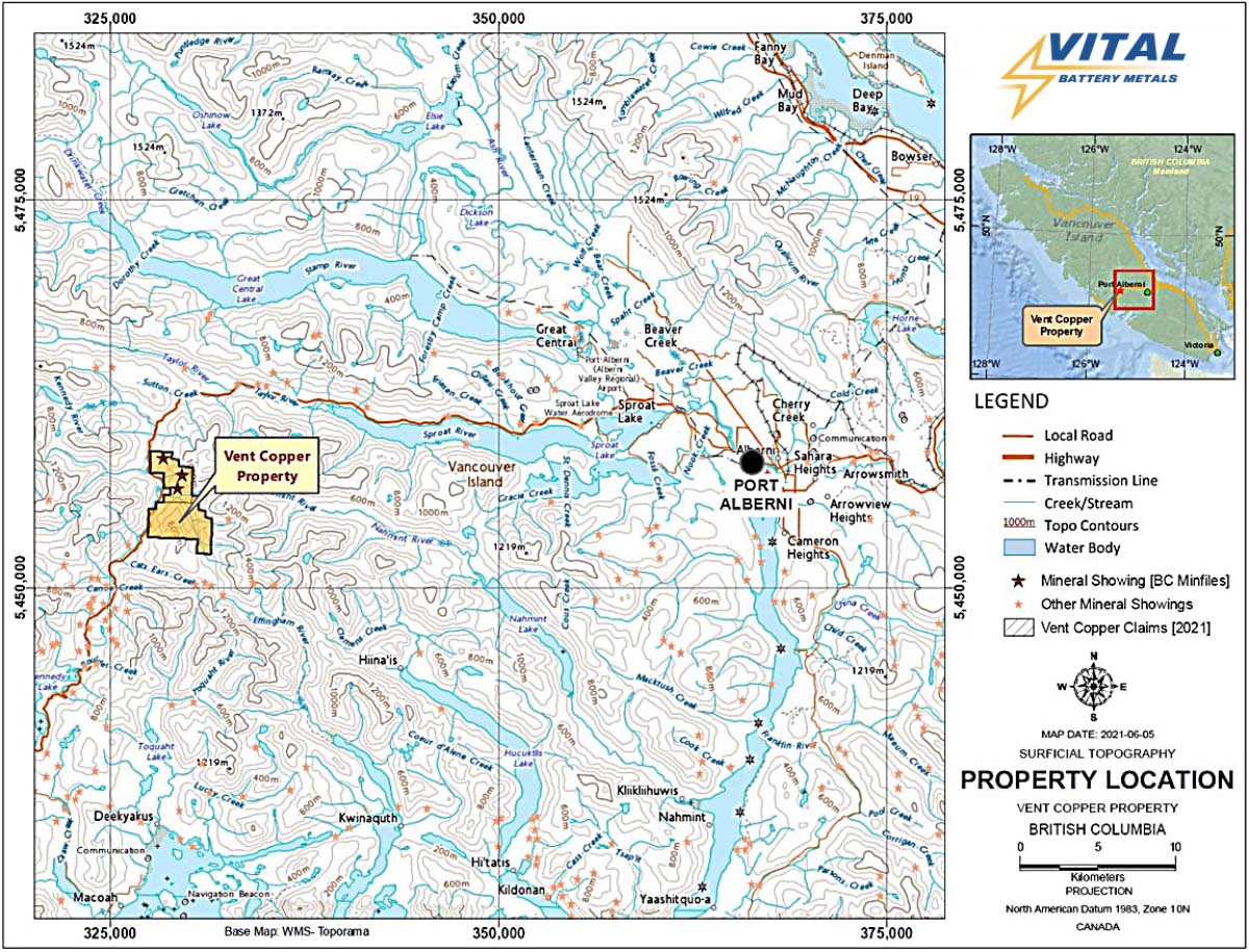
The Property consists of two contiguous mining claims covering approximately 1,562 hectares on crown land approximately 51 kilometers west of Port Alberni on Vancouver Island.
Location
The Vent Copper Property is situated in the Alberni Mining District, located on Vancouver Island in southwest British Columbia, approximately 51 kilometers west of Port Alberni.It is accessible from Vancouver via BC Ferries or air via Nanaimo.
The western portion of the Property can be directly accessed by Pacific Rim Highway (HWY/ BC-4 W) from Port Alberni which crosses part of the property.
A network of secondary logging roads of varying quality provides further access to various portions of the claims.
Kennedy River along the western boundary of the Property and other local creeks are good sources of water for exploration and mining work.
The Property has an ideal location for shipping potential minerals by ocean freight to any destination in the world.
Click image to enlarge.
Click image to enlarge.
EARLY EXPLORATION
EARLY EXPLORATION
Exploration dates to early 1960’s when anomalous copper values were discovered in stream sediments.
The Geological Survey of Canada mapped a number of igneous bodies intruding Triassic Volcanics in 1965 in the claim area.
W.G. Stevenson conducted a silt sampling program in the area with the map as a guide and the assay results from sixteen samples varied from 45 to 578 ppm copper and from 0.5 to 20 ppm molybdenum. The area was staked by Stevenson in 1968.
During 1969 and 1970 geological, geochemical and geophysical programs were conducted concluding that the area is mainly underlainby volcanic rocks with intrusions in places. Anomalous copper and molybdenum concentration found in the soil samples and increased magnetic intensities were noted in places.
In 1972, three diamond drill holes were completed in order to test an area of abundant pyrite mineralization. The exploration activities generally halted in the area after 1975.
RECENT EXPLORATION
RECENT EXPLORATION
From June 7 to August 15, 2021, further exploration work was done on the property including geological mapping, prospecting, sampling and ground geophysical surveying (magnetic and VLF).
The focus of the fieldwork was to carry out detailed sampling of mainly Karmutsen Formation and island intrusions and to identify prospective geological units and
rock formations.
A total of 124 grab (include six samples for data verification) and chip rock samples were collected from rock outcrops and along logging roads on the property. Out of 124 samples collected, 11 samples were field duplicates. The sampling program was designed to represent various prospective geological units and
rock formations.
The ground geophysical survey program comprised of a Very Low Frequency (VLF) and magnetic (MAG) survey. A total of 633 measurements were recorded along a north-south profile about 10-12m station intervals on approximately 8,075m of traverse line with a GEM GSM-19 portable magnetometer and VLF-EM system.
Results obtained from the survey indicate several target areas which are zones that express high MAG and relatively strong VLF responses. These target areas are zones or features of interest with highest potential for further investigations.
Geology
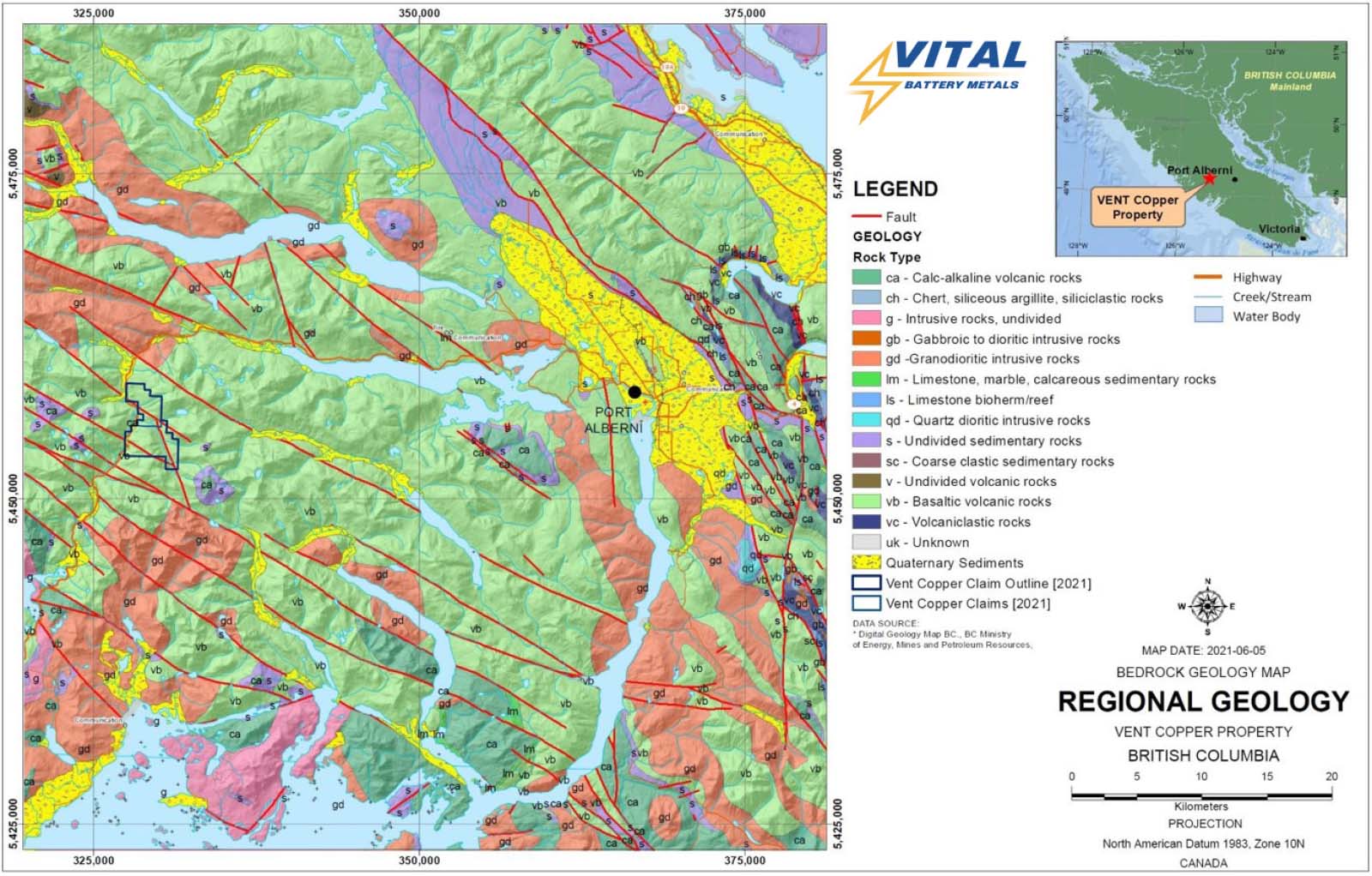
Geologically, Vancouver Island belongs to the Insular tectonic belt, the western most major tectonic subdivision of the Canadian Cordillera.
The area is underlain by two major groups of volcanic and sedimentary rocks that are respectively upper Paleozoic and lower Mesozoic in age.
Paleozoic and Jurassic complexes are unconformably overlain by two major groups of clastic sediments laid down in shallow marine or continental basins, one of late Mesozoic and one of Tertiary age.
Granitic rocks, formed during at least two separate plutonic events in Middle to Late Jurassic and in Tertiary time, outcrop throughout the island.
Click image to enlarge.
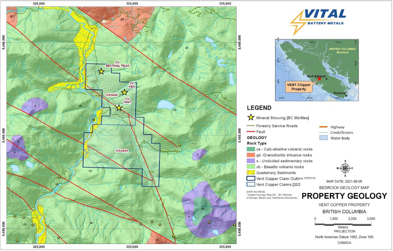
Locally, the claims are underlain by rocks of Karmutsen Formation consisting of pillow-basalt and pillow-breccia, basaltic lava and minor tuff and limestone of Upper Triassic and older to Lower Jurassic in age, and Island intrusions.
The volcanic rocks in the Property are cut by veins and veinlets of milky quartz, highly pyritized and rust stained at many locations. Disseminated and stringers of pyrite are occasionally up to 15-20%.The Island intrusions include Quartz- Monzonite, Hornblende-Monzonite, Quartz-Diorite and Diorite, although quartz-monzonite and quartz-diorite are the dominant rock types.
The dominant structural feature of the area is steep faulting. These faults generallytrend northwesterly with subsidiary faults striking north to north-easterly.
Bedding attitudes in the Karmutsen Formation in the vicinity of the Property suggest that the area is part of an anticlinal structure with roughly a north-south to northeast-southwest trend on the western limb.
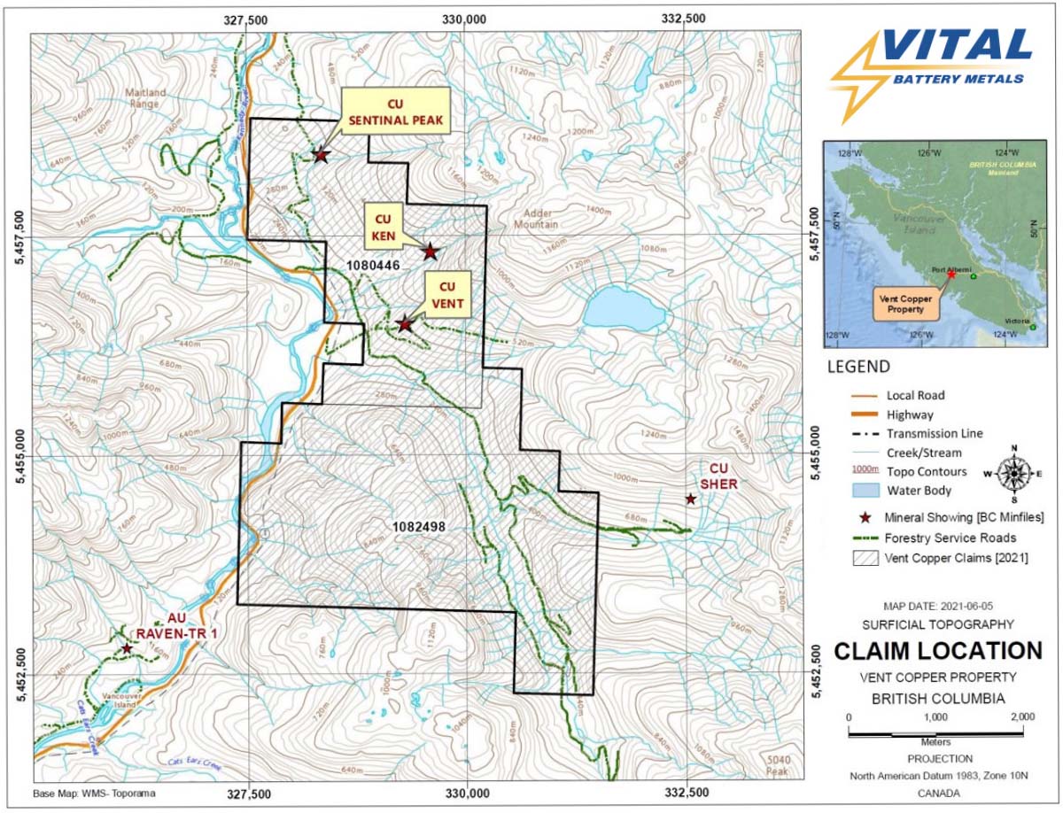
Three mineral showings on the Property, mainly copper, are in very early stage
of exploration.
Although, the property does not host any major previous or present mines, it is surrounded by past producing mines and a number of known and well explored deposits.
The data collected from these mines and exploration work and research work conducted in these areas provide a good understanding of the geology and mineralization.
Click image to enlarge.
Click image to enlarge.
Exploration Results
Out of 124 samples, one sample contained 1.25%, 21 samples range from 1000 ppm-4750 ppm and 79 samples are from 116 ppm – 1000 ppm.
The highest value (1.25 %) sample (# 102879) is collected from the vicinity of the Cu Ken showing. Generally, higher values are in the central part of the claim 1080446.
2021 sampling results show copper in the range of 4.9 ppm to 1.25%, silver 0.01 ppm to 7.78 ppm (gram per ton). In 1975, a 3-metre chip sample from one shear zone assayed 0.42 per cent copper with individual samples up to 2.45 per cent copper.
Samples of amygdaloidal basalt containing chalcopyrite assayed in excess of 0.5 per cent copper and up to 1.7 per cent copper.
The 2021 field season included a ground geophysical program comprised of a Very Low Frequency (VLF) and magnetic (MAG) survey. A total of 633 measurements were recorded along a north-south profile about 10-12m station intervals over approximately 8,075m.
Several High Priority Target Areas Identified
Results obtained from MAG/VLF lines in the survey areas indicate that the target areas of (A), (B), (C), (D), (E), (F) and (G) are zones that express high MAG and relatively strong LVF responses. These target areas are zones or features of interest with highest potential for further investigations.
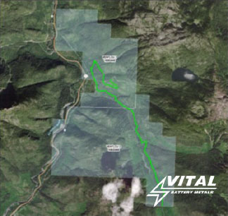
Location of the MAG / VLF Geophysical Survey. Click image to enlarge.
Location of historial diamond drill holes and mineral showings.
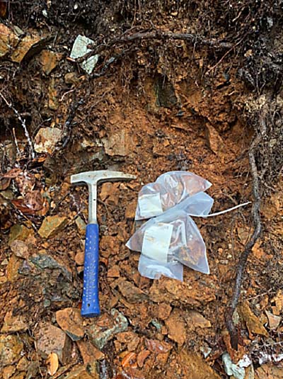
Brown sheared zone clay Sample # 102880. Click image to enlarge.
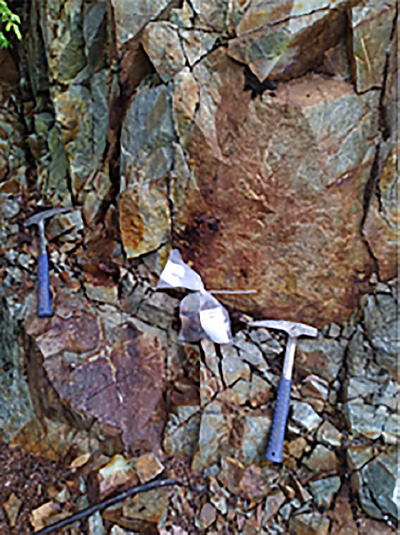
Iron-Stained Andesite Location Sample # 102851. Click image to enlarge.
WORK PLAN
Phase 1 – Prospecting, Mapping, Sampling and Geophysical Surveys
The following target areas were identified during 2021 exploration work program which need a follow up prospecting, mapping, sampling and geophysical surveying work on the Property.
The area around Vent-Ken showing has indicated good values of copper and needs a follow up detailed sampling as well as mapping to establish a working deposit model for the area.
The MAG and VLF-EM survey suggest further ground truthing of the Magnetic and VLF anomalies is recommended to determine if those anomalies are related to mineralization, fault zones, structural contacts, or overburden response.
Geological mapping and comprehensive soil sampling along with a soil chemistry analysis are suggested to be conducted in areas where the magnetic HIGHS suggest near surface features and in areas where the high VLF responses corroborate well with the magnetic HIGHS.
Phase 2 – Drilling
Based on the results of Phase 1 program, a drilling program is recommended to be executed on the targets if identified for further work on the Property.