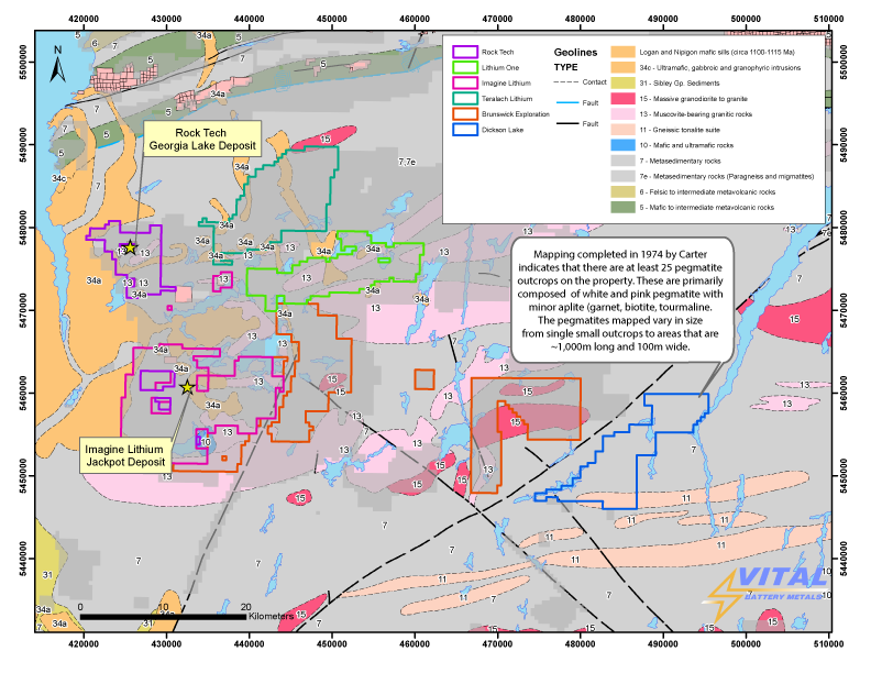
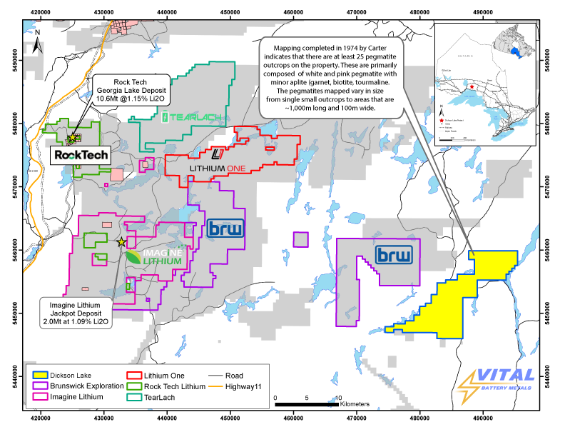
The Project consists of 445 single-cell mining claims and 1 multi-cell mining claim totaling 464 units covering approximately 9,780 hectares and is located approximately 50km north of Terrace Bay, Ontario. The Project is easily accessible year around by Wintering Rd. and logging road networks. The Project is southeast of the Brunswick Exploration’s Georgia Lake Lithium project.
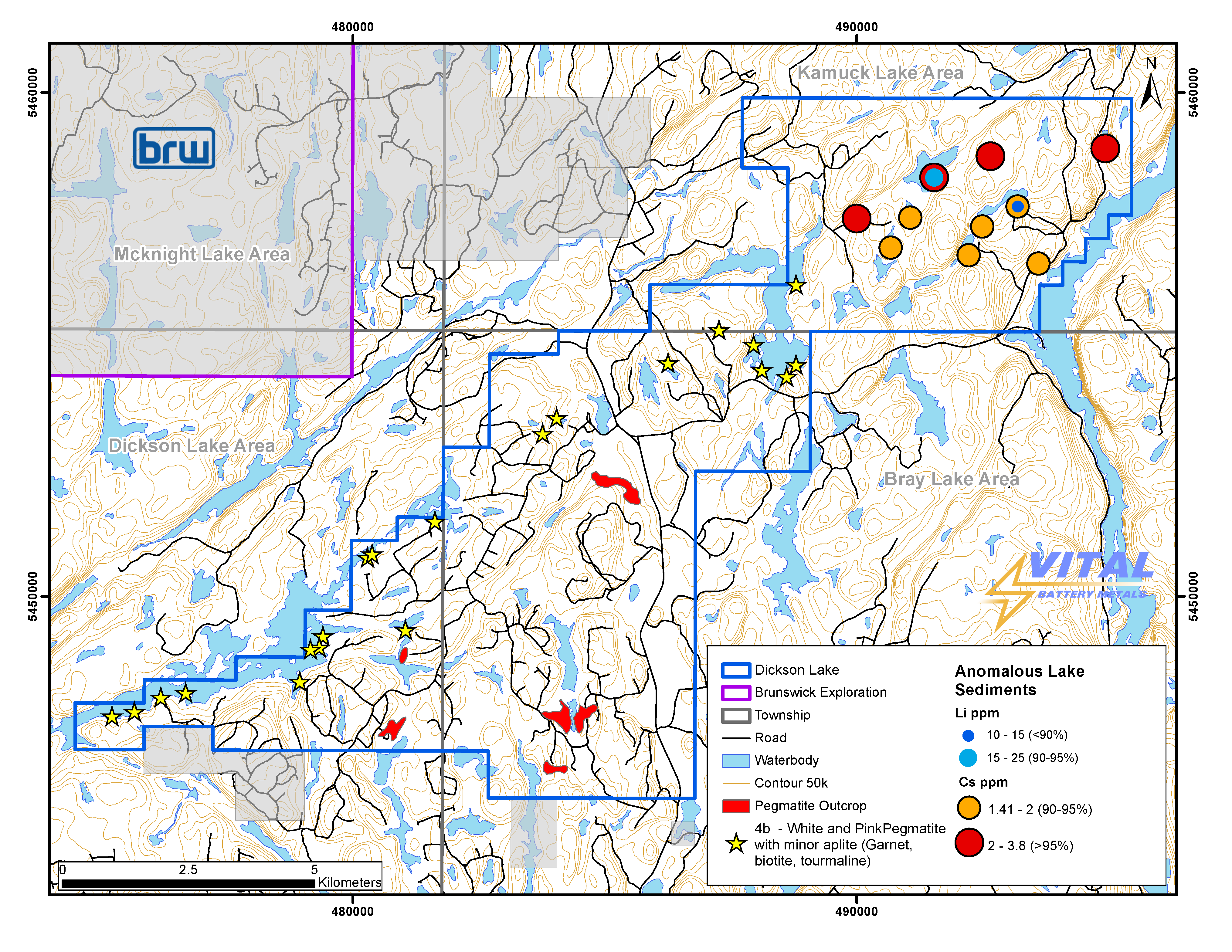
There are 25 mapped pegmatite outcrops on the Project which have not been thoroughly tested for LCT (Lithium, Cesium, Tantalum) mineralization.
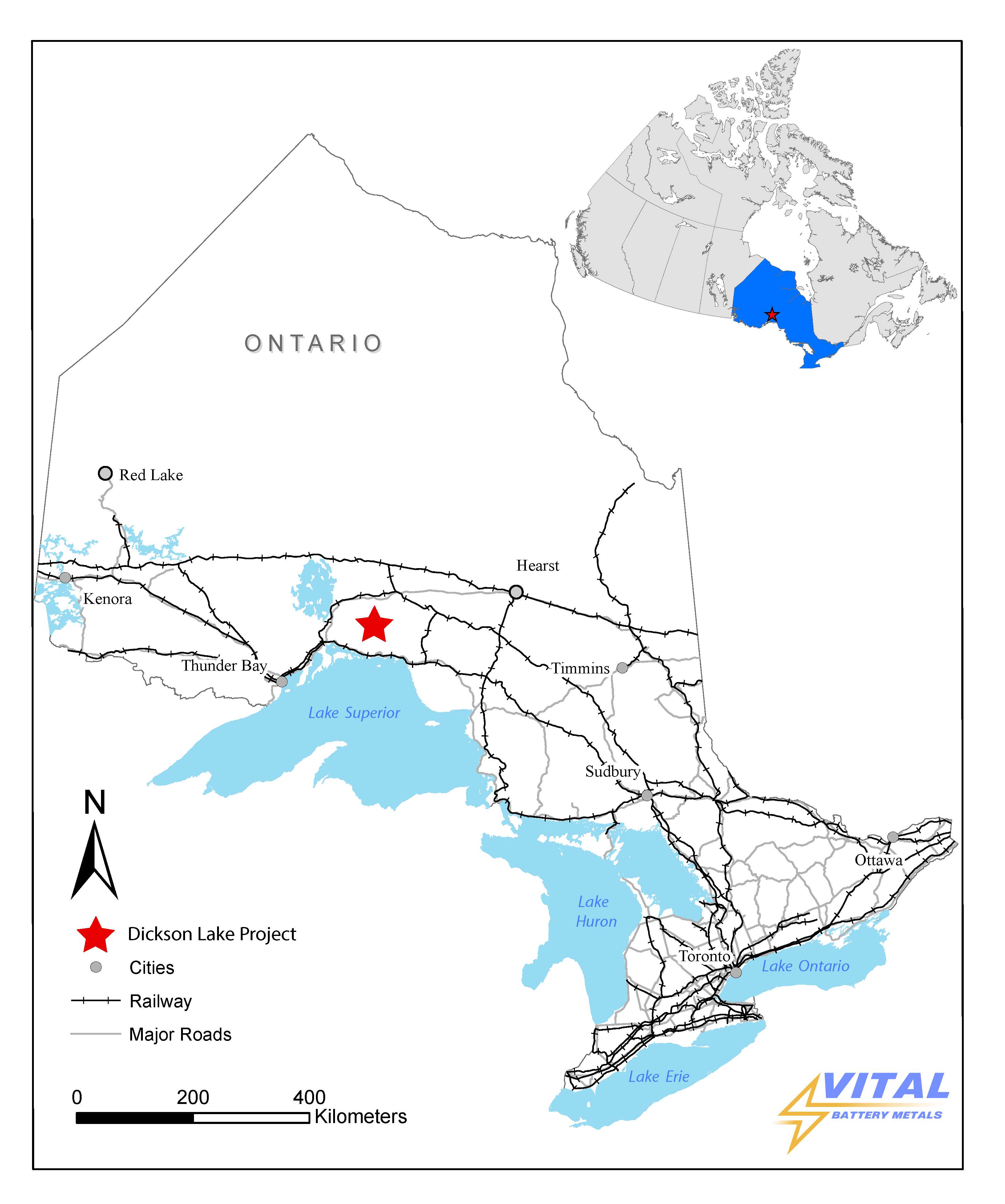
The Property is located in the Dickson Lake, Bray Lake, and Kamuck Lake Area of the Thunder Bay Mining Division.
Click image to enlarge.
Location
The Property is located in the Dickson Lake, Bray Lake, and Kamuck Lake Area of the Thunder Bay Mining Division. The nearest population centre is Terrace Bay, ON which is located 50km south. The Project is accessed by taking Wintering Rd north from Trans-Canada Highway 17 for 50km, this transects the property and there are arterial logging roads which allow access to the extents of the property. Wintering Rd is an all season road.
Click image to enlarge.
PREVIOUS WORK
PREVIOUS WORK
The project has been underexplored but has seen sporadic exploration for base metals in the late 1980’s. No work completed on the project has been focused on the economic potential of the pegmatites present.
Rock Tech has recently completed a Pre-Feasibility Study for the project, which includes pre-tax net present value at an 8% discount rate (“NPV”) of USD 223 million at an average life of mine (“LOM”) price of USD 1,500 /t, 6% spodumene concentrate (“SC6”).
Estimated pre-tax internal rate of return (“IRR”) of 47.8% at an average LOM price of USD 1,500/t, SC6.
LOM of 9 years, with low-cost open pit mining for the first 4 years and underground mining for the last 5 years. Pre-tax payback of 2.9 years.
Adjacent to Imagine Lithium’s Jackpot Deposit, which has a historical Resource of 2 MT of Li2O and is currently being drilled for additional Lithium targets.
Adjacent to Brunswick Explorations Property.
Click image to enlarge.
Geology
The property is situated within the Quetico subprovince, an Archean aged terrane comprised predominantly of metasedimentary gneiss, derived migmatites, granitoid intrusives and amphibolite. The rocks have undergone regional metamorphism to almandine-amphibolite facies. Metasedimentary rocks are dominantly greywacke in composition, with lesser arenite and arkose. Migmitization of these metasediments is generally pervasive with some sections remaining unaffected. Intrusive bodies range in composition from granite to quartz monzonite and are, for the most part, in gradational contact with migmatite.
Project is underlain by metasediments, derived migmatites, and felsic intrusives which are crosscut by predominantly northwest and northeast trending dikes and steeply dipping faults. Regional grade of metamorphism is amphibolite faces.
Claims were staked based on preferred geologic environments and historical mapping, most of this area has seen little to no exploration.
Mapping completed in 1974 by Carter indicates that there are at least 25 pegmatite outcrops on the property. These are primarily composed of white and pink pegmatite with minor aplite (garnet, biotite, tourmaline. The pegmatites mapped vary in size from single small outcrops to areas that are 1,000m long and 100m wide. Although the previous mapping indicates that there are pegmatites present on the Project, the company has yet to determine the dimensions, extent, or any mineralization that may be present on the Project. The project has been underexplored but has seen sporadic exploration for base metals in the late 1980’s.
Click image to enlarge.
Click image to enlarge.
REFERENCES
Carter, M.W. 1975: Geology of the Dickson Lake Area. District of Thunder Bay; Ontario Div. Mines. GR123, 28p. Accompanied by Map 2293, Scale 1 inch to 1 mile.
QUALIFIED PERSON
QUALIFIED PERSON
The technical information contained in this news release has been reviewed and approved by Mr. Garry Clark, P.Geo., a “Qualified Person” as defined in National Instrument 43-101 – Standards of Disclosure for Mineral Projects.
The reader is cautioned that the mineralization on nearby or adjacent properties does not necessarily indicate that any mineral resources may be discovered on the Dickson Lake Lithium Project, or if discovered, that such resources would be economically recoverable.